Surveying 6h5sx
This document was ed by and they confirmed that they have the permission to share it. If you are author or own the copyright of this book, please report to us by using this report form. Report r6l17
Overview 4q3b3c
& View Surveying as PDF for free.
More details 26j3b
- Words: 1,567
- Pages: 7
MINE SURVEYING - I Subject Title
:
Mine Surveying - I
Subject Code
:
MNG-305
Periods per week
:
05
Periods per semester
:
75
TIME SCHEDULE S. No
Major Topics
No. of Periods
Weightage of Marks
Short Answer Type
Essay Answer Type
1
Introduction
08
13
1
1
2
Linear Measurements
15
19
3
1
3
Com Surveying
10
13
1
1
4
Levelling
19
26
2
2
5
Contouring and Subsidence
08
16
2
1
Theodolite Surveying part-I
15
23
1
2
75
110
10
08
6
Total
OBJECTIVES After the completion of these topics the student should be able to 1.0
Know the preliminaries of Surveying
1.1
Define the term Surveying.
1.2
List the objectives of surveying.
1.3
State the principles of surveying.
1.4
List the primary divisions of surveying.
1.5
Give the broad classification of surveying.
1.6
Define the term (a) Plan (b) Map (c) Scale of a Plan
1.7
List the Plans and Sections required for Mining
1.8
Explain the maintenance of Plans and Sections as per CMR 162
2.0
Know the Linear Measurements
2.1
Classify the methods of measuring distances.
2.2
List the instruments for direct measurement of distances.
2.3
Describe the constructional details of chain and tape.
2.4
Define the term ranging.
2.5
Classify the ranging methods.
2.6
Describe the method of direct ranging.
2.7
Describe the method of indirect ranging.
2.8
Define the term Offset
2.9
List the types of Offsets and applicability of each.
2.10 Name the instruments for setting offsets. 2.11 Explain the method of measuring distances on level ground. 2.12 Explain the method of measuring distance on sloping ground (Stepping method). 2.13 State the purpose of chain surveying. 2.14 State the principle of chain surveying. 2.15 List the steps in chain surveying. 2.16 Define the term Reconnaissance. 2.17 Explain the term Reference sketch. 2.18 State the term well-conditioned triangle 2.19 List the types of survey stations. 2.20 In Chain triangulation define the (a) Base line (b) Check line(c) Tie line 2.21 List the factors governing the selection of station. 2.22 Describe the chain triangulation to find the area of a field 2.23 Calculate the area of an irregular figure by Simpson's rule 2.24 List the sources of errors in measuring distances. 2.25 List the reasons for incorrect length of chain. 2.26 State the corrections to be applied to the measured length for obtaining true length. 163
2.27 Solve the problems to obtain true length, true areaand true volumes. 2.28 List the common mistakes in surveying. 2.29 State the permissible limits of error in measurement of distances with chain and tape. 3.0
Know the Com Surveying
3.1
State the uses of com.
3.2
List the types of comes.
3.3
State the parts of Prismatic com with sketch.
3.4
Define the (a) TrueMeridian (b) Magnetic Meridian (c) Arbitrary meridian
3.5
State the termbearing
3.6
Classify the types of bearings (Whole circle bearing,Quadrantal bearing, Fore bearing, Back bearing).
3.7
Explain the method of measuring the magnetic bearing of line, with prismatic com.
3.8
Describe the traversing with com and chain.
3.9
Convert the whole circle bearings to quadrantal bearing and vice versa.
3.10 Explain the (a) included angle (b) interior angle (c) exterior angle. 3.11 Define the (a) Traverse (b) Closed traverse (c) 'Open Traverse 3.12 Compute the included angles from the bearings of the lines. 3.13 Define the term local attraction. 3.14 List the reasons for local attraction. 3.15 Solve the simple problems on local attraction. 3.16 Define the (a) Magnetic Declination (b) Dip. 3.17 Solve the problems on Magnetic Declination. 3.18 State the permissible limit of the error in (Prismatic) Com survey. 164
4.0
Understand the Levelling
4.1
Define the term Levelling.
4.2
List the objectives of Levelling.
4.3
Explain the principle of levelling.
4.4
Define of (a) level surface (b) level line (c) horizontal plane (d) Horizontal line (e) Vertical plane ( f) Vertical line (g) Datum surfaceor datum line (h) elevation (i) bench mark (j) Line of collimation (k) Axis of telescope (l) Axis of bubble tube (m) Vertical axis (n) Back sight (o) Foresight (p) intermediate sight (q)change point (r) Station (s) Height of instrument (t) Reduce level.
4.5
List different types of levelling instruments.
4.6
Describe the Dumpy level.
4.7
List the temporary adjustments of dumpy level.
4.8
List the fundamental lines of dumpy level.
4.9
State the relations between the fundamental lines of dumpy level.
4.10 List the types of levelling staves. 4.11 List the methods of Levelling 4.12 Explain the (a)Simple levelling (b) Compound levelling. 4.13 Explain the methods of reducing Levels from the observed staff readings. 4.14 Calculate the reduced levels by Rise and Fall methods. 4.15 Calculates the reduced levels by Height of Instruments. 4.16 Describe the profile levelling method. 4.17 State the applicability of profile levelling. 4.18 Explain the effects of (a) Curvature (b) Refraction in levelling. 4.19 State the correction for (a) curvature (b) Refraction (c)combined effect of both of them in Levelling 4.20 Describe the method of Reciprocal levelling. 4.21 State its applicability and merits of Reciprocal levelling 165
4.22 Solve related problems on reciprocal levelling. 4.23 State the permissible limits of error in (a) Ordinary levelling (b) Rough levelling (c) Precise levelling (d) Underground levelling in establishing bench marks of important nature. 5.0
Contouring and Subsidence
5.1
State the purpose of subsidence levelling.
5.2
State the purpose of highest flood level.
5.3
Define the (a) contour (b) contour interval (c) Horizontal equivalent of contour (d) stratum contours (e) Isopachyte (f) Grade contour.
5.4
List the methods of contouring.
5.5
Describe the direct method of contouring.
5.6
Describe the square method of contouring.
5.7
List the uses of contour for mining engineer.
5.8
List the Characteristics of contours.
6.0
Understand theodolite survey.
6.1
Describe transit Vernier theodolite.
6.2
List the uses of theodolite
6.3
List the fundamental lines of a transit theodolite
6.4
List the relations between the fundamental lines.
6.5
List the permanent adjustments of a transit theodolite.
6.6
Define the (a) transiting (b) Swinging (c) Face left (d) Face right (e) changing face (f) Index error as used in theodolite,
6.7
List the methods of measuring horizontal angle.
6.8
Describe the Repetition method of measurement of horizontal angle.
6.9
Describe the Reiteration method of measurement of Horizontal angle.
6.10 State the applicabilities of Repetition and Reiteration methods 6.11 Describe the method of measuring Vertical angle. 166
6.12 Describe the method of measuring the Magnetic Bearing of line with theodolite 6.13 List the method of traversing with theodolite 6.14 Describe the continuous Azimuth method of traverse. 6.15 Describe the double foresight method of traverse 6.16 State the checks on the accuracy of angular measurements in closed figures 6.17 Explain the term 'Permissible error of Closure' 6.18 State the permissible error of closure for (a) Surface traverse (b) Underground traverse
COURSE CONTENTS 1.0
Introduction: - Definition - Objectives - Classification - Principle -Primary Divisions of Surveying-Plan - Map - Scale of a Plan Plans and Sections for Mining - maintenance of Plans and Sections as per CMR
2.0
Linear Measurements:-Classification - Instruments Constructional details -- Ranging - Direct - Indirect -OffsetsMeasuring Distances on level Ground - Sloping Ground Purpose - Principle - Steps - Reconnaissance - Reference sketch-Survey stations- Baseline - Tie line- Chain triangulationFinding the area by Simpson's rule -Reasons for incorrect length of Chain - Sources of Errors - Corrections - Problems Mistakes - Permissible Limits.
3.0
Com Surveying:- Uses - Types - Purpose of parts - Turemeridian - Magnetic Meridian - Arbitrary Meridian Bearing Whole Circle - Quadrantal - F. B - B. B - Methods of Measuring Bearings- conversion W.C.B to Q.B, Q.B to W.C.B, Computes Included Angle - Local Attraction - Reasons - solves Problems on Local Attraction - Magnetic Declination & Dip Open & Closed Traverse - Traversing with Com and chain - Permissible errors.
4.0
Levelling:- Definitions - Type of Instruments - Adjustments Fundamental Lines - Relations - Principles of levelling 167
Methods - Curvature and Refraction Reciprocal Levelling Merits - Applicability - Problems - Permissible Errors 5.0
Contouring and Subsidence: Purpose of Subsidence Levelling - Purpose of H.F.L - contour - contour interval Horizontal equivalent of contour - stratum contours - Isopachyte - Grade contour - Method of contouring - Direct - Square-Uses - Characteristics
6.0
Theodolite: Description of Vernier Theodolite - fundamental lines relation between fundamental lines - Temporary and permanent adjustments - Definition of Various Measurement of horizontal angles - repetition, reiteration methods measurement of vertical angle- magnetic bearing of lines.Traversing - continuous Azimuth, double fore sight methods - computation of bearings of traverses check of accuracy in angular measurements - permissible error for surface and underground
TEXT BOOKS: 1.
Ghatak., Mining Surveying, Lovely Prakashan,Dhanbad,1990.
2.
Punmia, B.C., Surveying Vol I and II, Laxmi Publication, New Delhi, 1991
3.
Kenetkar, T.P., Surveying and Levelling, Vol I and Vol II, United Book Corporation, Poona, 1991.
REFERENCES BOOKS 1.
Mason,E., Coal Mining Series, Surveying ,Vol I And Vol II, Virtue And Company Limited, London.
2.
Clark, D., Plane And Geodetic Surveying,Vol I And Vol II, CBS Publishing Co., 1986.
3.
Assur,V.L.And Pilatov,A.M., Pratical Guide To Surveying MIR Publishers, Moscow 1988.
4.
Borshch,V., Komponiets,A., Navitny, G.And Knysh., Mine Surveying MIR Publishers Moscow,1989.
5.
Sahni, Advanced Surveying, Lovely Prakashan, Dhanbad, 1992.
6.
Alam Chand., Modern Concept Of Mine Survey, Lovely Prakashan, Dhanbad,1992.
7.
Surveying by arora Vol 1,2,3. ***** 168
:
Mine Surveying - I
Subject Code
:
MNG-305
Periods per week
:
05
Periods per semester
:
75
TIME SCHEDULE S. No
Major Topics
No. of Periods
Weightage of Marks
Short Answer Type
Essay Answer Type
1
Introduction
08
13
1
1
2
Linear Measurements
15
19
3
1
3
Com Surveying
10
13
1
1
4
Levelling
19
26
2
2
5
Contouring and Subsidence
08
16
2
1
Theodolite Surveying part-I
15
23
1
2
75
110
10
08
6
Total
OBJECTIVES After the completion of these topics the student should be able to 1.0
Know the preliminaries of Surveying
1.1
Define the term Surveying.
1.2
List the objectives of surveying.
1.3
State the principles of surveying.
1.4
List the primary divisions of surveying.
1.5
Give the broad classification of surveying.
1.6
Define the term (a) Plan (b) Map (c) Scale of a Plan
1.7
List the Plans and Sections required for Mining
1.8
Explain the maintenance of Plans and Sections as per CMR 162
2.0
Know the Linear Measurements
2.1
Classify the methods of measuring distances.
2.2
List the instruments for direct measurement of distances.
2.3
Describe the constructional details of chain and tape.
2.4
Define the term ranging.
2.5
Classify the ranging methods.
2.6
Describe the method of direct ranging.
2.7
Describe the method of indirect ranging.
2.8
Define the term Offset
2.9
List the types of Offsets and applicability of each.
2.10 Name the instruments for setting offsets. 2.11 Explain the method of measuring distances on level ground. 2.12 Explain the method of measuring distance on sloping ground (Stepping method). 2.13 State the purpose of chain surveying. 2.14 State the principle of chain surveying. 2.15 List the steps in chain surveying. 2.16 Define the term Reconnaissance. 2.17 Explain the term Reference sketch. 2.18 State the term well-conditioned triangle 2.19 List the types of survey stations. 2.20 In Chain triangulation define the (a) Base line (b) Check line(c) Tie line 2.21 List the factors governing the selection of station. 2.22 Describe the chain triangulation to find the area of a field 2.23 Calculate the area of an irregular figure by Simpson's rule 2.24 List the sources of errors in measuring distances. 2.25 List the reasons for incorrect length of chain. 2.26 State the corrections to be applied to the measured length for obtaining true length. 163
2.27 Solve the problems to obtain true length, true areaand true volumes. 2.28 List the common mistakes in surveying. 2.29 State the permissible limits of error in measurement of distances with chain and tape. 3.0
Know the Com Surveying
3.1
State the uses of com.
3.2
List the types of comes.
3.3
State the parts of Prismatic com with sketch.
3.4
Define the (a) TrueMeridian (b) Magnetic Meridian (c) Arbitrary meridian
3.5
State the termbearing
3.6
Classify the types of bearings (Whole circle bearing,Quadrantal bearing, Fore bearing, Back bearing).
3.7
Explain the method of measuring the magnetic bearing of line, with prismatic com.
3.8
Describe the traversing with com and chain.
3.9
Convert the whole circle bearings to quadrantal bearing and vice versa.
3.10 Explain the (a) included angle (b) interior angle (c) exterior angle. 3.11 Define the (a) Traverse (b) Closed traverse (c) 'Open Traverse 3.12 Compute the included angles from the bearings of the lines. 3.13 Define the term local attraction. 3.14 List the reasons for local attraction. 3.15 Solve the simple problems on local attraction. 3.16 Define the (a) Magnetic Declination (b) Dip. 3.17 Solve the problems on Magnetic Declination. 3.18 State the permissible limit of the error in (Prismatic) Com survey. 164
4.0
Understand the Levelling
4.1
Define the term Levelling.
4.2
List the objectives of Levelling.
4.3
Explain the principle of levelling.
4.4
Define of (a) level surface (b) level line (c) horizontal plane (d) Horizontal line (e) Vertical plane ( f) Vertical line (g) Datum surfaceor datum line (h) elevation (i) bench mark (j) Line of collimation (k) Axis of telescope (l) Axis of bubble tube (m) Vertical axis (n) Back sight (o) Foresight (p) intermediate sight (q)change point (r) Station (s) Height of instrument (t) Reduce level.
4.5
List different types of levelling instruments.
4.6
Describe the Dumpy level.
4.7
List the temporary adjustments of dumpy level.
4.8
List the fundamental lines of dumpy level.
4.9
State the relations between the fundamental lines of dumpy level.
4.10 List the types of levelling staves. 4.11 List the methods of Levelling 4.12 Explain the (a)Simple levelling (b) Compound levelling. 4.13 Explain the methods of reducing Levels from the observed staff readings. 4.14 Calculate the reduced levels by Rise and Fall methods. 4.15 Calculates the reduced levels by Height of Instruments. 4.16 Describe the profile levelling method. 4.17 State the applicability of profile levelling. 4.18 Explain the effects of (a) Curvature (b) Refraction in levelling. 4.19 State the correction for (a) curvature (b) Refraction (c)combined effect of both of them in Levelling 4.20 Describe the method of Reciprocal levelling. 4.21 State its applicability and merits of Reciprocal levelling 165
4.22 Solve related problems on reciprocal levelling. 4.23 State the permissible limits of error in (a) Ordinary levelling (b) Rough levelling (c) Precise levelling (d) Underground levelling in establishing bench marks of important nature. 5.0
Contouring and Subsidence
5.1
State the purpose of subsidence levelling.
5.2
State the purpose of highest flood level.
5.3
Define the (a) contour (b) contour interval (c) Horizontal equivalent of contour (d) stratum contours (e) Isopachyte (f) Grade contour.
5.4
List the methods of contouring.
5.5
Describe the direct method of contouring.
5.6
Describe the square method of contouring.
5.7
List the uses of contour for mining engineer.
5.8
List the Characteristics of contours.
6.0
Understand theodolite survey.
6.1
Describe transit Vernier theodolite.
6.2
List the uses of theodolite
6.3
List the fundamental lines of a transit theodolite
6.4
List the relations between the fundamental lines.
6.5
List the permanent adjustments of a transit theodolite.
6.6
Define the (a) transiting (b) Swinging (c) Face left (d) Face right (e) changing face (f) Index error as used in theodolite,
6.7
List the methods of measuring horizontal angle.
6.8
Describe the Repetition method of measurement of horizontal angle.
6.9
Describe the Reiteration method of measurement of Horizontal angle.
6.10 State the applicabilities of Repetition and Reiteration methods 6.11 Describe the method of measuring Vertical angle. 166
6.12 Describe the method of measuring the Magnetic Bearing of line with theodolite 6.13 List the method of traversing with theodolite 6.14 Describe the continuous Azimuth method of traverse. 6.15 Describe the double foresight method of traverse 6.16 State the checks on the accuracy of angular measurements in closed figures 6.17 Explain the term 'Permissible error of Closure' 6.18 State the permissible error of closure for (a) Surface traverse (b) Underground traverse
COURSE CONTENTS 1.0
Introduction: - Definition - Objectives - Classification - Principle -Primary Divisions of Surveying-Plan - Map - Scale of a Plan Plans and Sections for Mining - maintenance of Plans and Sections as per CMR
2.0
Linear Measurements:-Classification - Instruments Constructional details -- Ranging - Direct - Indirect -OffsetsMeasuring Distances on level Ground - Sloping Ground Purpose - Principle - Steps - Reconnaissance - Reference sketch-Survey stations- Baseline - Tie line- Chain triangulationFinding the area by Simpson's rule -Reasons for incorrect length of Chain - Sources of Errors - Corrections - Problems Mistakes - Permissible Limits.
3.0
Com Surveying:- Uses - Types - Purpose of parts - Turemeridian - Magnetic Meridian - Arbitrary Meridian Bearing Whole Circle - Quadrantal - F. B - B. B - Methods of Measuring Bearings- conversion W.C.B to Q.B, Q.B to W.C.B, Computes Included Angle - Local Attraction - Reasons - solves Problems on Local Attraction - Magnetic Declination & Dip Open & Closed Traverse - Traversing with Com and chain - Permissible errors.
4.0
Levelling:- Definitions - Type of Instruments - Adjustments Fundamental Lines - Relations - Principles of levelling 167
Methods - Curvature and Refraction Reciprocal Levelling Merits - Applicability - Problems - Permissible Errors 5.0
Contouring and Subsidence: Purpose of Subsidence Levelling - Purpose of H.F.L - contour - contour interval Horizontal equivalent of contour - stratum contours - Isopachyte - Grade contour - Method of contouring - Direct - Square-Uses - Characteristics
6.0
Theodolite: Description of Vernier Theodolite - fundamental lines relation between fundamental lines - Temporary and permanent adjustments - Definition of Various Measurement of horizontal angles - repetition, reiteration methods measurement of vertical angle- magnetic bearing of lines.Traversing - continuous Azimuth, double fore sight methods - computation of bearings of traverses check of accuracy in angular measurements - permissible error for surface and underground
TEXT BOOKS: 1.
Ghatak., Mining Surveying, Lovely Prakashan,Dhanbad,1990.
2.
Punmia, B.C., Surveying Vol I and II, Laxmi Publication, New Delhi, 1991
3.
Kenetkar, T.P., Surveying and Levelling, Vol I and Vol II, United Book Corporation, Poona, 1991.
REFERENCES BOOKS 1.
Mason,E., Coal Mining Series, Surveying ,Vol I And Vol II, Virtue And Company Limited, London.
2.
Clark, D., Plane And Geodetic Surveying,Vol I And Vol II, CBS Publishing Co., 1986.
3.
Assur,V.L.And Pilatov,A.M., Pratical Guide To Surveying MIR Publishers, Moscow 1988.
4.
Borshch,V., Komponiets,A., Navitny, G.And Knysh., Mine Surveying MIR Publishers Moscow,1989.
5.
Sahni, Advanced Surveying, Lovely Prakashan, Dhanbad, 1992.
6.
Alam Chand., Modern Concept Of Mine Survey, Lovely Prakashan, Dhanbad,1992.
7.
Surveying by arora Vol 1,2,3. ***** 168
Related Documents 171j1w

Surveying 6h5sx
November 2022 0
Surveying 6h5sx
December 2020 0
Surveying 6h5sx
November 2019 86
Surveying 6h5sx
November 2021 0
Surveying 6h5sx
April 2020 47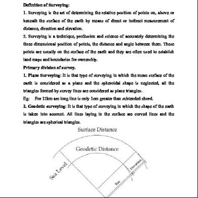
Chain Surveying And Com Surveying 1r582t
November 2021 0More Documents from "PK" 6f1822
Dsi Canada Dywidag Threadbar Imperial Units Ca 03 6p612j
October 2022 0
Specific Gravity Of Soil Solids 5d3z5e
November 2022 0
Analog Electronics Viva 71281e
November 2021 0
Surveying 6h5sx
November 2022 0
Habermas - The Philosophical Discourse Of Modernity 2p3f26
November 2019 151