The Branches Of Surveying 50283j
This document was ed by and they confirmed that they have the permission to share it. If you are author or own the copyright of this book, please report to us by using this report form. Report r6l17
Overview 4q3b3c
& View The Branches Of Surveying as PDF for free.
More details 26j3b
- Words: 259
- Pages: 1
THE BRANCHES OF SURVEYING :
Cadastral survey : Cadastral surveying is that branch of surveying which is concerned with the survey and demarcation of land for the purpose of defining parcels of land for registration in a land registry. Engineering survey : Engineering Surveying is an important disciplinary field that serves construction projects Hydrographic Survey : Hydrographic Survey is an instrumental survey to measure and determine characteristics of streams and other bodies of water extent, and depth of water in lakes or the ocean. Photogrammetry: Photogrammetry Is using cameras which are usually carried in airplanes to obtain images making measurements from photographs and also to determine the positions on photographed objects. Topography survey : Is about determining the relative locations of points (places) on the earth's surface by measuring horizontal distances, differences in elevation and directions
Remote sensing: Remote sensors is collect data by detecting the energy that is reflected from Earth. These sensors also can be on satellites or mounted on aircraft. Geographical Information System: A geographic information system (GIS) integrates hardware, software, and data for capturing, managing, analyzing, and displaying all forms of geographically referenced information. GIS also allows us to view, understand, question, interpret, and visualize data in many ways that reveal relationships, patterns, and trends in the form of maps, globes, reports, and charts. Global positioning system : is a space based satellite navigation system that provides location and time information in all weather conditions anywhere on or near the earth where there is an unobstructed line of sight to four or more GPS satellites.
Related Documents 171j1w

The Branches Of Surveying 50283j
November 2022 0
The Four Branches Of Philosophy 5m4d5i
November 2019 46
Surveying 6h5sx
November 2022 0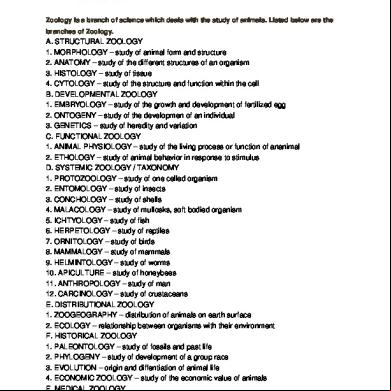
Branches Of Zoology 135n5k
November 2019 82
Branches Of Government Mobile 502665
December 2019 67