Fungsi Toolbar Pada Arcgis 12b1c
This document was ed by and they confirmed that they have the permission to share it. If you are author or own the copyright of this book, please report to us by using this report form. Report r6l17
Overview 4q3b3c
& View Fungsi Toolbar Pada Arcgis as PDF for free.
More details 26j3b
- Words: 387
- Pages: 3
FUNGSI TOOLBAR PADA ARCGIS Button
Name Zoom In
Function Untuk memperbesar jendela geografis dengan mengklik titik atau menyeret kotak
Zoom Out
Untuk memperkecil dari jendela geografis dengan mengklik titik atau menyeret kotak Memungkinkan Anda untuk memperbesar pada tengah frame data Anda
Fixed Zoom In
Fixed Zoom Out
Memungkinkan Anda untuk memperkecil di tengah frame data Anda
Pan
Memungkinkan Anda untuk menggeser frame data
Full Extent
Memungkinkan Anda untuk memperbesar ke tingkat penuh peta Anda
Back
Memungkinkan Anda untuk kembali ke tingkat sebelumnya
Forward
Memungkinkan Anda untuk maju ke tingkat berikutnya
Select Features
Fitur Pilih Memungkinkan Anda untuk memilih fitur dengan mengklik atau menyeret kotak
Clear Selected Features
Tidak memilih semua fitur yang dipilih saat ini dalam bingkai data aktif
Select Elements
Untuk memilih, mengubah ukuran, dan memindahkan teks, grafik, dan objek lainnya ditempatkan di peta
Identify
Mengidentifikasi fitur geografis atau tempat di mana Anda klik
Go To XY
Memungkinkan Anda untuk mengetik suatu lokasi x,y dan navigasi untuk itu
1
Measure
Mengukur jarak pada peta
Hyperlink
Pemicu hyperlink dari fitur
Edit Annotation
Edits annotation features
Construct Horizontal Annotation Construct Straight Annotation Construct Annotation With A Leader Line Unplaced Annotation Window Get Data
Sets up the editor to construct horizontal annotation Sets up the editor to construct straight annotation Sets up the editor to construct annotation with a leader line
Shows or hides the unplaced annotation window Copies data for use in Arad and checks out database layers for editing
Check In Edits
Updates your geodatabase with the field edits that were being used in ArcMap
Undo Check Out
Removes unwanted checkouts from the transaction log file
Traverse
Displays the Traverse window
Construct 2Point Line
Displays the 2-Point Line window, so you can construct a 2-point line using COGO methods
Offset Line
Create a line at a specified distance and perpendicular from a selected line
Cul-de-sac
Construct a cul-de-sac from a street centerline
Proportion
Splits the selected feature proportionally
2
Ground to Grid Correction
View and change the current direction offset and distance factor
COGO Report
Displays the COGO Report window
COGO Area
Reports the COGO area and other information for selected lines
Curve Calculator
Reports missing parameters for curves
Split into COGO Lines
Splits selected line features into new 2-point line features
Update COGO Attributes
Updates the COGO attributes from the geometry of the selected features
3
Related Documents 171j1w

Fungsi Toolbar Pada Arcgis 12b1c
November 2020 0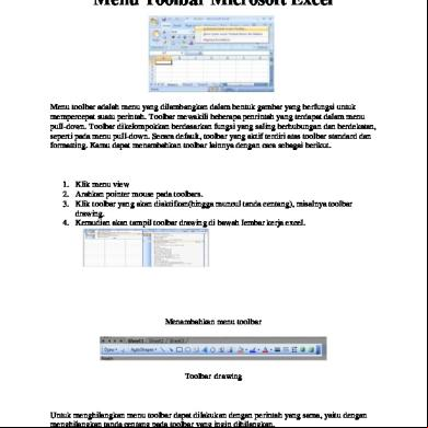
Menu Toolbar Pada Microsoft Excel 454p6d
November 2019 20
Tugas Fungsi Fungsi Menu Toolbar Ms Excel 2010 1h1c3
December 2020 0
Fungsi Rangka Pada Manusia 601o6f
November 2019 33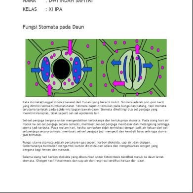
Fungsi Stomata Pada Daun 104e1e
November 2019 115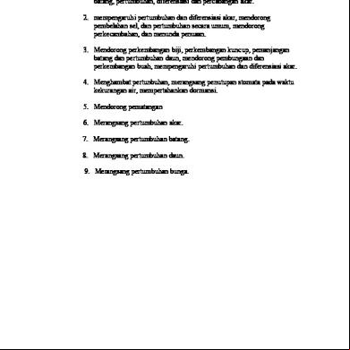
Fungsi Hormon Pada Tumbuhan 3b6d1o
November 2019 39More Documents from "Sunthi Wahyu Kinanthi" 286a4e
Fungsi Toolbar Pada Arcgis 12b1c
November 2020 0
Hasil Lengkap - Survei Simulasi Rs. Rumah Sehat Terpadu Dompet Dhuafa 2y103z
April 2020 52
Komplikasi Dyspepsia Fugsional.docx 5t2224
January 2022 0
Pencukuran Dan Teknik Aseptik Area Operasi 2017 6u4et
September 2020 0
Laporan Pendahuluan Apn Rsu.docx 236237
August 2020 0